What do these Rorschach ink blots look like to you? If your answer is “gerrymandering,” you’re perfectly sane — unlike the politicians who drew them.
Politics knows no bounds
Nationwide, Republicans and Democrats are steering our ship of state in circles, brushing up against every Titanic-killer iceberg they can find.
Their latest attempts to make red states redder and blue states bluer by redrawing congressional boundaries are just the ticket to making our country even more polarized.
We’ve already gerrymandered every last drop of common sense out of most of our district boundaries. Trying to do more is a great self-serving way to waste yet more time and money instead of actually trying to solve problems.
Still, all the hubbub might focus needed attention on great injustices about Marion being gerrymandered out of having any political clout at all levels of government.
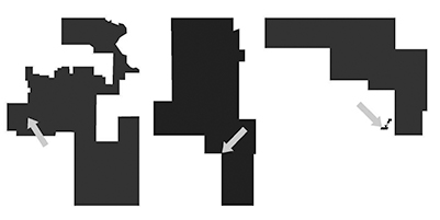
The massively irregular shapes above are, from left, Marion’s congressional district, its legislative district, and its county commissioner district. In each case, a gray arrow shows Marion within the district.
If this were Thanksgiving and Uncle Bob carved a slice of turkey the shape of Marion’s congressional district, you’d have to question whether he got into the eggnog a bit early.
Marion County is now the westernmost appendage to a bizarrely drawn district primarily focused on northeast and southeast Kansas. We were moved when legislators in their greed tried to take a couple of bites out of what otherwise would be a logically shaped district, representing similar areas.
The 1st District, representing largely rural areas in central and western Kansas, now includes very urban Lawrence and Douglas County, while we and other rural areas replace them in the more urban 2nd District.
Bad as that may seem, our legislative district is even worse. For most of its more than 160-year existence, Marion County has fit within a single district. It has now been carved into two, having minority status in both.
Worst of all is Marion’s county commissioner district. That little dot that looks like a desert island offshore is the north half of Marion. The south half is in a different district. And in both cases, Marion is a decided minority within district dominated by more rural areas.
Hillsboro similarly is divided into two districts, with one chunk of Hillsboro being isolated from the rest of the district to which it belongs. But in Hillsboro’s case, it dominates both of the districts. If you’re keeping score, that’s Hillsboro 2, Marion 0.
Not only are the districts drawn to maximize the clout of rural interests. They haven’t been updated, as all the other districts have, with the latest census figures on population. The area around Marion was the only part of the county to have grown in the 2020 census, but these boundaries were drawn well before the census came out.
County commissioners need to show more sense than state legislators and revisit commission district boundaries with an eye toward respecting city or township boundaries, keeping districts contiguous, and not worrying about whether redistricting might pit one incumbent against another.
Laws typically require that districts be redrawn after decennial censuses are completed. That didn’t happen with our commissioner districts. Better late than never.
— ERIC MEYER